Ohana
Avg: 5.3knts
24hr: 128nm
arrived Opua marina. Thanks very much to Patricia, David and Mike from Gulf Harbour Radio and YIT for a season of excellent weather information and a really well designed website, especially mike for implementing the special text message satphone weather service. We'll be sleeping through the radio sched today but we'll miss you!
Avg: 8.3knts
24hr: 198.9nm
On final approach to Opua ETA 0400 and the wind has died, looking forward to a good but short sleep before being rudely awakened by customs!
Avg: 6.1knts
24hr: 145.3nm
wind s10kn. Cloud 5/10.1020mb. Speed 5kn. Cog 115t. Trysail down main up again. All's well.
Avg: 7.7knts
24hr: 185nm
wind sw18kn g32kn. Cloud 9/10.1015mb. Speed 8kn. Cog 155t. All's well.
Avg: 8.7knts
24hr: 208.2nm
wind sw19kn gusts 25-35. Cloud 8/10.1016mb. Speed 6.5kn.Cog 160t.Busy morning.Mainsail down trysail up.All's well.
Avg: 8knts
24hr: 191.6nm
land ho! norfolk island in sight! wind sw16kn. Cloud 6/10.1015mb. Speed 9kn. Cog 170t. All's well.
Avg: 8knts
24hr: 192nm
wind sw10kn.Cld 4/10.1017mb. Speed 6kn. Cog160t. Will wave at norfolk island & proceed direct to nz.All's well.
Avg: 6.7knts
24hr: 160.2nm
wind sw14kn g18kn.Cld 9/10.1016mb.Spd 8kn.Cog 150t.Just entered band of showers.we'll decide soon norfolk or not.
Avg: 6.6knts
24hr: 157.4nm
wind wsw8kn. Cld 0/10.1016mb.Speed 6.5kn. Cog 165t.6 hrs good sailing overnight but motor on again now.All's well.
Avg: 7knts
24hr: 168.3nm
wind sw5kn. Cloud 1/10.1014mb. Speed 6.5kn Motorsailing.Cog 175t. Beautiful sunny day. All's well.
New Cal to NZ
Avg: 5.5knts
24hr: 132.9nm
wind 0kn. Cloud 1/10.1016mb. Speed 5kn. Cog 200t. Motoring south to find some wind. All's well.
departing noumea in one hour bound for Opua with a possible pause at Norfolk Island to wait for weather, looks like we will miss the elections in scotland, fiji and NZ!
preparing to depart Wednesday afternoon and head for Opua with a possible stop at Norfolk island depending on weather.
Avg: 4.7knts
24hr: 111.9nm
hove to off noumea waiting for marina to awaken. Sunday so may have to wait aboard til tomorrow for customs.
Avg: 6.1knts
24hr: 145.9nm
wind se15kn.Cld 1/10.1016mb.Spd 5kn.Cog 158t.Running engines to push round cap des pins against current.alls well.
Avg: 4.8knts
24hr: 114.1nm
wind se7-12kn. Cloud 3/10 .1016mb. Speed 5kn. Cog 200t. ETA Noumea 2 days from now. All's well.
Avg: 4.7knts
24hr: 114nm
wind se7kn. Cloud 3/10. Patches rain passed earlier. 1015mb. Speed 4kn (occ. 6kn motorsailing). Cog 190t. All's well.
cleared customs, departed port vila, three POB (chris, ryan & geoff), course over ground 185t, speed 5kn, wind se 12kn, 1/10 cloud
departing port vila in the morning bound for new caledonia.
arrived port vila this morning, lots to do now before we leave!
departing Revolieu bay in a few hours bound for port vila. ETA 0700
Fresh lobsters for dinner at uliveu, $10 for two! tomorrow we snorkel at the giant clam sanctuary.
just departed malokilikili en route to port stanley or maskelines. 4pob. 5kn ne wind occ. shower, 9/10 cloud
oyster island, peterson bay has been lovely. departing tomorrow to start working back south in short hops. Now 4POB with a 5th possibly joining us tomorrow. No wind for days, where did the trade winds go?
arrived luganville, anchored at beachfront resort. Wind E7kn
arrived nopul, staying here 3 days for the rom dance festival
Avg: 5.1knts
24hr: 122.3nm
a peaceful night in Lamen bay, epi island
departed havannah harbour under sail heading for epi island. sunny morning 1/10 cloud, wind se15 10kn here in middle of harbour
departing port vila 3pob heading for havannah harbour wind se15 patchy cloud
Avg: 9.4knts
24hr: 225.4nm
approaching port vila.Speed 6kn.Cog 260t eta1030 wind dropped 10-15se
Avg: 9.3knts
24hr: 222.9nm
course og 255t spd 9 kn, occasionally 12! Trade wind steady ese 18kn.Cloud 2/10.No rain. Eta vila 08-1200 tomorrow
Avg: 8.4knts
24hr: 202.4nm
course 290t. speed 8kn. all is well after a moonlit night with patchy cloud, no rain.
cleared customs and departed Lautoka 1040 local time. ETA port vila monday afternoon. 5kn S wind here inshore off vuda point, motoring at 5.5kn
preparing to depart friday morning from lautoka bound for port vila, vanuatu
back in the mamanucas, currently at Mana island
Avg: 2.6knts
24hr: 61.8nm
Anchored at Nanuya Sewa Island, Blue Lagoon
departed navidamu 1015, no wind at the moment, hope it picks up away from the land. Probably destination Blue Lagoon ETA 1500 tomorrow.
after three days with the super-friendly villagers of Navidamu we will depart in the morning for the Yasawa group, passage expected to take about 26 hours via raviravi passage, and outside the great sea reef. 4POB, wind SE10
spent two wonderful days with the people of naviqiri village, N coast of vanua levu
Been at musket cove for a couple of days, heading out to yasawa group soon.
At beachcomber island - will try to post photos in blog section
anchored at treasure island catching up on some jobs
Avg: 6.5knts
24hr: 157nm
Arrived Lautoka, anchored and having a barbecue - awaiting customs clearance tomorrow.
approaching navula passage clear sky wind ene7kn,0cloud getting hot. Eta 1200 entrance,1800lautoka. Next update when we have internet.
Avg: 8.4knts
24hr: 202.4nm
cog355ttill doing over 8 knots avg under trysail!
Avg: 8.7knts
24hr: 209.6nm
ohana is a reaching machine! Swapped main for trysail due to broken batten.
Still doing 8kn in 15kn e wind! Cog005t eta sun eve
Avg: 9.3knts
24hr: 223.8nm
great day at 10kn yesterday, down to 6kn overnight. Cog 010t. Saw 3 strobe lights in the water at 24 47S and 177 03E and reported to maritime Radio. ETA Lautoka Saturday
Avg: 8.7knts
24hr: 208.4nm
still 8.5-9kn, wind e 17kn, cloud & lt rain, cog015t all's well
Avg: 9.7knts
24hr: 231.9nm
weather stable se15-18 occ. Showers,starry night 8.5kn 015cog
Avg: 7.6knts
24hr: 183.5nm
increased sail at dawn now doing 9kn 005cog wind ese16kn
Avg: 6.2knts
24hr: 149nm
steering 030t at 6kn wind s 15-20
on our way to fiji!
Cleared customs and departed opua. Forecast looks good and we are on our way!
arrived safely in opua, quick passage but dead downwind.
test message - departing nz soon
Ohana - Photos from the voyage to rapa
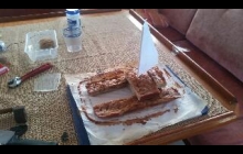
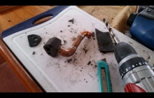
We're struggling to get usable Internet here but this is an attempt to upload some photos of my birthday cake and the pay we made for the engine on the way to rapa. Photos of rapa coming soon if this works!
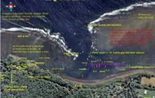
Ohana - Pilotage chart of Olal, Ambrym, Vanuatu
We were warmly welcomed by the villagers at Olal who have built a brand new yacht club and bar there and organise the annual Rom dances and Back to my roots festival. Unfortunately yachts never visit there and anchor an hour's walk away just because Olal is not in any of the cruising guides or pilot books. We decided to fix that and carried out a survey of the anchorage which we will submit to all the vanuatu cruising guides... here it is so you can be one of the first yachts to visit!
Further Read more...
Neighbouring Nopul is a good anchorage (Much better than Ranon) but it
means a very long walk to Olal including crossing a ford which can be impassable
after heavy rain. We spent 3 nights there before moving to Olal to do
the survey.
Olal has the new yacht club and bar and is where chief Sekur lives.
The Rom dances and two annual festivals are held about ten minutes
walk inland and everyone comes back to the yacht club afterwards.
While we were there the BBC were filming a documentary primarily about
the volcano but also featuring the dancing at Olal. The
villagers there are doing good things to raise money for the school,
keep their traditions alive and put on wonderful events where the
dances are very real, not just put on for tourists and they are making
a real effort to attract yachts. Chief sekur has travelled widely as a
cultural ambassador for Vanuatu. He can organise dances, pig feasts
and open the bar any time, all night on occasion! The chief at Nopul
was also very friendly but there is not much to do there.
I would say Nopul is the better anchorage in trade winds mainly
because it is bigger but on windy days you can get random gusts and
swing about there. In Olal the wind is less gusty and there is a
steady breeze which is better for ventilation and power generation,
not much swinging. The reef offers good shelter from all sides except
from the north. We had winds from due east and although the waves can
wrap around the end of the reef a bit our anchor location still had
very good shelter. It could be a little rolly right at the top of the
tide for a monohull but otherwise very calm.
The depth soundings were calibrated roughly to spring low tide.
The least depth I saw on the sounder as we swung at anchor was 1.9
metres and deeper water was available nearer to the entrance.
Waves were not a problem in the entrance at all in the conditions we
had but they did come over the reef towards the dinghy channel a bit
at dead high tide.
Locals reported that a major tsunami or storm surge a few years ago
had drastically altered the anchorage, destroying the wharf and
reducing the depth by several metres. silting up may be continuing and
the sands may still be shifting. Locals who came aboard were surprised
when they saw our depth sounder, expecting a lot more water (a small
cruise ship used to visit Olal until the wharf was destroyed).
We had only about 15m of chain out, there would be room for maybe 2-3
big yachts in there on short scope if they are not too deep drafted, plus a
couple more cats if they have daggerboards.
Holding seemed very good but avoid the rubble near the reef, there
were a few larger boulders there which could snag an anchor.
A new airstrip is under construction at Olal near the school, nearing completion
now. I got the impression Olal hope to become the main transport hub as well
as already being the main cultural centre of Ambrym.
As the waves push water in over the reef the current appeared to always flow
towards and out of the entrance and can be strong between the inner pair of stakes
and in the small boat channels both sides of the harbour, especially in the first half
of a falling tide. this current probably helps reduce swinging but might make it
unsafe to swim.
To download the chart - click on the image of it at the top left of this blog. A bigger but still squashed version will appear. Right click on that and select "save image as..." or the equivalent option in your web browser to save the full size image.
Ohana - Beachcomber island
Beachcomber island is welcoming to yachts and has moorings available. Free mooring with $10/person landing fee. It's a backpacker resort on a tiny island. (Etai island according to the charts)


