The Southern Cross
Report at 0730 24 November (Queensland time) Moored at Raby Bay. Glorious day.
Report at 0630 21 November (Queensland time) Anchored at Peel Island, Moreton Bay.
Report at 0730 20 November (Queensland time) Anchored at St Helena Island in Moreton Bay just south of the entrance to the Brisbane River. Had a reasonable overnight sail down from Double Island Point, arriving here at 1300 yesterday. Maximum wind was 20 kts and the only issue for us was the large number of ships entering and leaving Moreton Bay.
St Helena Island is named after St Helena Island in the South Atlantic where Napoleon spent his last days. This St Helena Island was also a prison and is now inhabited by hundreds of wallabies and many varieties of shore birds and land birds. It is wonderful to be able, perhaps for the first time since the Galapogas Islands, to be able to observe land based wildlife up close and in abundance.
Report at 1115 18 November (Queensland time) Anchored at Double Island Point in 5m at high tide. Yesterday crossed Wide Bay Bar two hours before high tide. Minimum depth 5.6 metres, no breaking waves. 1m sea and 1m swell with 10 to 15 knots from SE. As we tacked our way to Double Island Point encountered a squall with over 30 knots of wind and heavy rain. Boats two miles to seaward saw 23 knots and light rain. Plan to sail overnight to Moreton Bay.
Report at 0515 17 November (Queensland time) Anchored at Inskip Point, Tin Can Bay, Queensland. Hoping to cross the Wide Bay Bar this morning
Report at 0545 16 November (Queensland time) Anchored at Kingfisher Resort Fraser Island, Queensland. Enjoyed a walk ashore yesterday. Heard dingos howling as the full moon rose. We can hear kookaburras this morning
Report at 1730 15 November (Queensland time) Anchored at Cape Vernon in southern Hervey Bay. Mostly good sail down from Bundaberg Port Marina. Had great time at Down Under Rally welcome week. Boat surrounded by thousands of butterflies.
Avg: 3.8knts
24hr: 91nm
Report at 2200 31 October (Queensland time) Arrived safely at Bundaberg Port Marina at 1400 today. A sporty sail across Hervey Bay. Crossed our outward path and completed our circumnavigation this morning. Celebrated with 40 cruisers and champagne provided by the Go West Rally. It was a wonderful evening.
Congratulations. Well done
Avg: 5.6knts
24hr: 133.5nm
In tonight to join the party. Well done
Congratulations Catherine and
Well done guys!!
Avg: 6.8knts
24hr: 162.4nm
Report at 0430 30 October (Queensland time) Only 122 miles to run to complete our circumnavigation. All is well on board.
Avg: 6.8knts
24hr: 163.6nm
Report at 0520 29 October (New Caledonia time) Just left the tropics. Squalls overnight. Pleasant conditions now. Enjoyed Peter's delicious risotto yesterday and looking forward to homemade pizza today. Still have bananas. All is well on board.
Avg: 6.9knts
24hr: 164.5nm
Report at 0520 28 October (New Caledonia time) Enjoyable trade wind sailing. All is well on board.
Avg: 5.8knts
24hr: 139.2nm
Report at 0500 27 October (New Caledonia time) Enjoyable trade wind sailing. All is well on board.
Avg: 3.5knts
24hr: 85nm
Report at 0530 26 October (New Caledonia time) Departed New Caledonia via Dumbea Pass at 1630 local, where we saw hundreds of birds on the wing. All is well on board.
Report at 0545 25 October (New Caledonia time) Underway, headed for Ile Nge for the day to prepare boat for departure to Bundaberg.
Hope you have a safe trip to
Report at 0515 24 October (New Caledonia time) Anchored at Baie de l'Orphelinat. Plan A: after reviewing the weather this morning, we will check out of New Caledonia, departing tomorrow or Wednesday.
Report at 0515 22 October (New Caledonia time) Anchored at Baie de l'Orphelinat. Preparing the boat for passage to Australia.
Report at 0540 19 October (New Caledonia time) Moored with 20 boats at Ilot Maitre, New Caledonia. Another beautiful calm morning. Good snorkelling yesterday with new (for us) varieties of fish plus turtles and cuttlefish.
Report at 0530 18 October (New Caledonia time) Anchored at Uere Bay, New Caledonia. Beautiful morning. Enjoyed watching young children learning how to sail in 'Optiene' boats yesterday.
Report at 0530 16 October (New Caledonia time) Anchored at Uere Bay, south of Noumea, New Caledonia. Reasonable protection from the strong winds we've had for the past two days.
Report at 0530 15 October (New Caledonia time) Anchored at Baie des Citrons, New Caledonia. Attended the well conducted and informative Down Under Rally event yesterday. Rain held off last evening till we were back on board; thank you David.
Report at 0545 14 October (New Caledonia time) Anchored at Ile Bailly. Beautiful little island covered with dense foliage. Navionics chart says it is a bird sanctuary however we have seen no birds and the main bird noise is a crowing rooster.
Report at 0545 13 October (New Caledonia time) On a mooring at Ile Casy, Baie de Prony. Interesting snorkel around reef. Colourful staghorn coral in good condition. Chainsaw and whippersnipper maintenance gang arrived yesterday and re-started work at 0515 this morning.
Report at 0520 12 October (New Caledonia time) On a mooring in Anse Majic, Baie de Prony. Had a great sail up from Isle of Pines yesterday. Went for a walk to the lighthouse in the afternoon, wonderful views from the top.
Report at 0530 11 October (New Caledonia time) Just underway from Ile des Pins to Baie de Prony. Small lumpy seas. The sun is about to rise above the Island. Heavy rain last evening with distant thunder. Lovely trip around the island yesterday by hire car.
Report at 0545 10 October (New Caledonia time) Anchored in Kuto Bay, Ile des Pins. Heavy rain for 15 mins approx 0330 local time. One clap of thunder heard after rain finished. No wind at the time.
Report at 0600 7 October (New Caledonia time) Still anchored in Kuto Bay, Ile des Pins. Hopefully no cruise ship today. Off to climb N'ga peak this morning.
Report at 0800 6 October (New Caledonia time) Anchored in Kuto Bay, Ile des Pins. Delightful trip across oily calm lagoon yesterday. Able to see the bottom 17m below when crossed a shallow section. Saw a dugong swim near the boat as we were anchoring. So many turtles in this bay.
Report at 1745 4 October (New Caledonia time) Moored at Ile Casy in the Baie du Prony. Beautiful island inhabited by a dog who doubles as the tour guide. Will head off for Ile des Pins at first light.
Report at 0545 4 October (New Caledonia time) Still anchored in Baie des Citrons near Noumea. Beautiful morning. Checked into country yesterday by dinghying in to Customs etc. Plan to leave today for Ile des Pins. Should arrive Wednesday afternoon.
Avg: 3.1knts
24hr: 75.2nm
Report at 0530 3 October (New Caledonia time) Safe landfall at Baie des Citrons at 1pm local time yesterday.
Avg: 7.8knts
24hr: 187.4nm
Report at 0520 1 October (Vanuatu time) Enjoying a fast sail to New Caledonia. Strongest gust of wind 22 knots. ETA at Havannah Pass is midnight.
Report at 0520 30 September (Vanuatu time) About to depart for New Caledonia
Report at 0545 29 September (Vanuatu time) Still anchored at Port Vila, Efate Island. Planning to depart for New Caledonia this evening or tomorrow morning.
Report at 0600 Tuesday 27 September (Vanuatu time) Still anchored off Port Vila, Efate Island. Lovely visit to museum yesterday and great food in Spice Indian restaurant.
Report at 0600 Monday 26 September (Vanuatu time) Anchored off Port Vila, Efate Island.
Avg: 3.3knts
24hr: 78.7nm
Report at 0530 Saturday 24 September (Vanuatu time) Approaching Port Vila, Efate Island with 4 miles to go. A comfortable trip down from Epi Island with maximum wind 17 knots. Initially (1200 local) the wind came from the SW and then clocked through W, NW to NE.
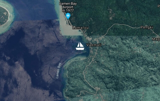
Report at 0530 Friday 23 September (Vanuatu time) Anchored Lamen Bay, Epi Island. Good coral out on the SW point, best to go at high tide. Have seen lots of turtles from the boat.
Report at 0530 Thursday 22 September (Vanuatu time) Anchored Lamen Bay, Epi Island. Had a fabulous sail on flat seas from SW corner of Ambryn to Lamen Bay. There was great visibility which enabled us to see the islands which are normally cloaked in haze. We saw four turtles when snorkelling off the boat.
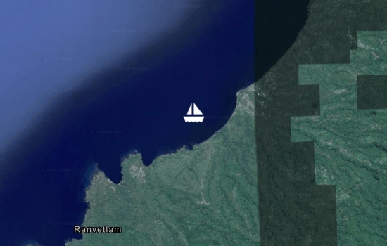
Report at 0445 21 September (Vanuatu time) Still anchored near Ranvetlam Village, Ambryn Island. Visited Ranvetlam Kindergarten yesterday morning. Delightful children whom we taught 'Old MacDonald's Farm' using local dialect for the names of the animals. Note for visiting yachts. Kindergarten has scant resources. Materials for basic craft eg paper, coloured pencils and picture books would be useful. Heading for Epi Island today.

Report at 0445 20 September (Vanuatu time) Moved less than a mile to anchored near Ranvetlam Village, Ambryn Island. Anchored in 10 metres black sand to be closer to friends on their boat. Lovely walk along coastal track to friendly Ranvetlam Village.
Report at 0730 19 September (Vanuatu time) Anchored off Ranon Village, Ambryn Island in 12 metres black sand. A conference encouraging leadership for women in the Presbyterian Church in Ambryn Island is being held in Ranon this week. Last night saw the glow of nearby active volcanoes.
Report at 0840 Saturday 18 September (Vanuatu time) Anchored off Londot, southern Pentecost Island. Open roadstead anchorage. Flat calm overnight as no wind. Anchored in 10m and dropped back into 15m. Good holding. Went ashore, walked northwards along the road and met Paulo and his family in Lonton Village. Paulo guided us to the amazing land diving structure. Able to buy bananas here. No bananas available in Asanvari on Maewo Island due to impact of Cyclone Winston earlier this year.
Report at 1700 Friday 16 September (Vanuatu time) Still anchored in Asanvari Bay, Maewo Island. Flat water. Wind funnels from all points of the compass so allow plenty of swinging room. Plenty of clear sand. Avoid scattered bommies mostly closer to shore. The locals are welcoming and keen to have visitors here. We snorkelled yesterday over a large bommie on the SW point and were joined by a large dugong. This was a thrill for us as it is the first time we have seen a dugong while snorkelling. The water clarity here is exceptional which enhanced our view of the dugong. Hot fresh bread was delivered to our boat this morning. Asanvari's attractions include Alex's waterfall and Carl's snorkelling tour.
Report at 0900 Wednesday 14 September (Vanuatu time) Anchored in Asanvari Bay, Maewo Island. Up to 33 knots of wind on our 12 mile trip from Loltong Bay yesterday. Sitting on flat seas, can see and hear a waterfall from the boat, lush green vegetation surrounds the anchorage.
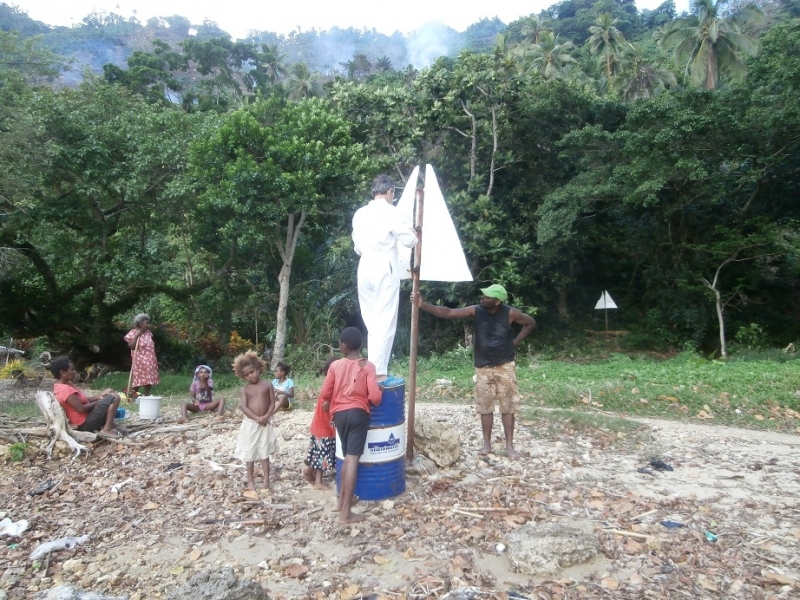
Report at 0545 Tuesday 13 September (Vanuatu time) Anchored in Loltong Bay, Pentecost Island. Yesterday we walked up the hill to the gardens and gained a view over the anchorage. In the afternoon, Peter worked with Matthew, who runs the local yacht club, to repair and repaint the leads. Hopefully this will make it easier for vessels to see the safe way to enter the pass.
Report at 0545 Monday 12 September (Vanuatu time) Anchored in Loltong Bay, Pentecost Island. Enjoyed a 12 course local cuisine feast yesterday, cooked by Mary, at the Vatulo Yacht Club, Loltong Bay. Some good snorkelling in the anchorage, found a turtle which was asleep and plenty of nemos that were awake.
Report at 0545 Saturday 10 September (Vanuatu time) Anchored in Loltong Bay, Pentecost Island. Arrived yesterday afternoon during a white out. Waited one hour, still no visibility. Entered tricky anchorage with caution. Thank goodness for Google Earth.
Report at 0515 Friday 9 September (Vanuatu time) Anchored in Banam Bay, Malekula Island. About to set sail for Pentacost Island.
We had to snorkel around the anchorage in order to find a spot which was completely coral-free. The snorkelling on the reef on the eastern side of the anchorage is only average. All of the staghorn coral was destroyed by cyclone Pam with a corresponding cut in the fish stocks. Some of the hard corals are impressive.
Unfortunately it seems that there are no Kastom Dances being held here this year. We have been asked by John Eddy (sp) to encourage cruisers to visit next year when they will hold dance demonstrations for yachties and other visitors. They are trying to work out a way of advertising the shows so that people have advance notice and can make plans.
Report at 0530 Thursday 8 September (Vanuatu time) Anchored in Banam Bay, Malekula Island.
Report at 0615 Wednesday 7 September (Vanuatu time) Anchored in Port Sandwich, Malekula Island. Light rain overnight.
Report at 0600 Tuesday 6 September (Vanuatu time) Anchored in Port Sandwich, Malekula Island. Tried anchoring closer to shore but anchor chain rumbling on coral and rocks. Anchored further out in mud. Supply ship came in during the night, so glad we weren't anchored too close to the wharf. The locals were busy yesterday digging trenches with shovels in order to lay pipes which will carry water from a dam to the village. The project is funded by the NZ government.
Report at 0530 Monday 5 September (Vanuatu time) Now anchored in Gaspard Bay adjacent to the Maskelynes Islands off Malekula Island. Came here in search of dugongs. Have seen a few fleeting glimpses of the seacow. This is a beautiful bay surrounded by mangroves. Entering the bay required careful navigation due to surrounding reefs. Yesterday Peter was a VIP at Lamen Bay Presbyterian Church as it was Father's Day.
Report at 0600 Sunday 4 September (Vanuatu time) Moved nearer to the beach in Lamen Bay to avoid a small bommie fouling our anchor chain. Now in clear sand all around. Happy Father's Day today to all Fathers. We enjoyed Peter's birthday yesterday swimming with turtles. Went ashore where Elsie gave us a large hand of bananas. Eating delicious bread baked by Ellen (Joseph's wife). 100 vatu a loaf. Going to attend the Presbyterian Church service at 7.00 am then leave for the Maskelyne Islands 25 nautical miles to the west.
Report at 0545 Friday 1 September (Vanuatu time) Anchored at Lamen Bay, Epi Island. Strongest wind overnight 28 knots.
Report at 0545 Thursday 1 September (Vanuatu time) Anchored at Lamen Bay, Epi Island. Lovely anchorage, good snorkelling, no dugongs in sight yet. Had a comfortable sail yesterday from Emae Island under jib. Maximum true wind 29 knots, two metre following seas.
Report at 0530 Wednesday 31 August (Vanuatu time) Anchored at Sulua Bay, Emae Island. Had a sporty sail yesterday from Efate Island under jib. Maximum true wind 25 knots, two metre seas.
Avg: 32.7knts
24hr: 784nm
Report at 0530 Tuesday 30 August (Vanuatu time) Anchored at Esema Bay, Havannah Harbour, Efate Island. Poor holding in soupy mud. Departing for Emae Island.
Report at 1200 Monday 29 August (Vanuatu time) Anchored at north east end of Lelepa Island. Dinghied around through the pass to the NW end of Lelepa. Drift snorkeled over beautiful corals outside the pass,.
Report at 0530 Monday 29 August (Vanuatu time) Anchored at Black Sands, Mele Bay, Vanuatu. Attended the Sunset Circus on Sundays at Beach Bar. Wonderful mix of comedy, traditional dance and acrobatics with a little fire thrown in for good measure.
Report at 0545 Friday 26 August (Vanuatu time) Enjoying Port Vila Bananas, along with a variety of other fresh produce is available at the market. Twisties, Vegemite and baguettes for sale in the supermarket.
Report at 0600 Thursday 25 August (Vanuatu time) Anchored in Vila Bay, Port Vila.
Avg: 5.6knts
24hr: 134.5nm
Report at 0530 Wednesday 24 August (Vanuatu time) 15nm to Port Vila.
Report at 0545 Tuesday 23 August (Vanuatu time) The Southern Cross is the only boat anchored in Port Resolution, Tanna Island. Saw the spectacular Mt Yasur Volcano yesterday.
Report at 0540 Monday 22 August (Vanuatu time) Departed Aneityum at 0300 local, headed for Tanna Island, Vanuatu. Still in the lee of Aneityum Island.
Report at 06000 Saturday 20 August (Vanuatu time) Still anchored at Ateityum, Vanuatu. Sunshine yesterday morning when we went snorkelling. Wore wetsuits as the water is COLD. Squalls in the afternoon and evening.
Report at 0550 Friday 19 August (Vanuatu time) Still anchored at Ateityum, Vanuatu.
Report at 0600 Thursday 18 August (Vanuatu time) Still anchored at Ateityum, Vanuatu. Very cool here. Temperature below 20 Celsius. Cold wind. We enjoyed the first ever Aneityum music festival last evening. Four boats at anchor, two from Port Adelaide.
Report at 0600 Wednesday 17 August (Vanuatu time) Strongest wind overnight 20 knots. Heavy rain showers yesterday afternoon. Warm welcome ashore. All is well on board.
Avg: 4.7knts
24hr: 112.2nm
Report at 0630 Tuesday 16 August (NZ time) Heading into anchorage at Aneityum, Vanuatu. 2 miles to go. All is well on board.
Avg: 6.7knts
24hr: 160nm
Report at 0630 Monday 15 August (NZ time) Underway Lautoka, Fiji to Aneityum, Vanuatu. 100 nautical miles to go. Nice spinnaker run yesterday.
Avg: 5.7knts
24hr: 137.5nm
Report at 0630 Sunday 14 August (NZ time) Underway Lautoka, Fiji to Aneityum, Vanuatu. Have come half way and now have 230Nm to run.
Avg: 5.3knts
24hr: 126.5nm
Report at 0630 Saturday 13 August (NZ time) Underway Lautoka, Fiji to Aneityum, Vanuatu. 360Nm to go. Strongest wind yesterday 33 knots with 3 metre seas.
Avg: 9.5knts
24hr: 228nm
Report at 0620 Friday 12 August (NZ time) Anchored off Lautoka, Viti Levu Island, Fiji. Will be checking out of Fiji this morning, headed for Aneityum in Vanuatu with ETA late Monday 15 August.
Report at 0630 Thursday 11 August (NZ time) Anchored off Lautoka, Viti Levu Island, Fiji. Planning to buy provisions today and check out of Fiji tomorrow, Friday 12 August
Report at 0630 Wednesday 10 August (NZ time) Still anchored off Musket Cove. Malolo Lailai Island, Fiji. Hoping to depart for Vanuatu Friday 12 August. Update 0700 blue sky seen to the west.
Report at 0630 Tuesday 9 August (NZ time) Still anchored off Musket Cove. Malolo Lailai Island, Fiji. It is still raining.
Report at 0645 Monday 8 August (NZ time) Still anchored off Musket Cove. Malolo Lailai Island, Fiji. Raining off and on, including heavy falls, since 4pm Saturday afternoon. Strongest wind overnight 20 knots. Strongest wind Friday late evening 30 knots.
Report at 0645 Saturday 6 August (NZ time) Anchored off Musket Cove. Malolo Lailai Island, Fiji. 30 boats in the anchorage.
Report at 0645 Friday 5 August (NZ time) Anchored near Lautoka, Viti Levu Island, Fiji. Our granddaughter was born in Adelaide yesterday. The first granddaughter after seven grandsons.
Hei, congratulations!!!
Report at 0630 Thursday 4 August (NZ time) Anchored near Lautoka, Viti Levu Island, Fiji. Found delicious dorsai masala at Hot Snax, Lauoka.
Report at 0650 Wednesday 3 August (NZ time) Anchored near Lautoka, Viti Levu Island, Fiji.
Report at 0630 Tuesday 2 August (NZ time) Still anchored in Saweni Bay near Lautoka, Viti Levu Island, Fiji.
Report at 0700 Monday 1 August (NZ time) Still anchored in Saweni Bay near Lautoka, Viti Levu Island, Fiji.
Report at 0630 Saturday 30 July (NZ time) Anchored in Saweni Bay, Viti Levu Island, Fiji.
Report at 0615 Friday 29 July (NZ time) Anchored in Yalobi Bay, Waya Island, Southern Yasawas, Fiji.
Report at 0645 Thursday 28 July (NZ time) Anchored in Yalobi Bay, Waya Island, Southern Yasawas, Fiji. SW swell is dropping. Yesterday morning we tried to anchor off west side of Waya Island near Octopus Resort but there was a heavy SW swell breaking on shore.
Report at 0630 Wednesday 27 July (NZ time) Anchored near Manta Ray Resort, Drawaqa Island, Yasawa Islands, Fiji. Wind gusting to 20 knots yesterday afternoon and evening. Enjoyed swimming with manta ray yesterday.
Report at 0645 Tuesday 26 July (NZ time) Anchored near Manta Ray Resort, Drawaqa Island, Yasawa Islands, Fiji. Sailed down from Somosomo Bay yesterday in lee of Naviti Island with wind up to 23 knots from the east. Overnight little wind. Wonderful drift snorkel yesterday in the pass.
Report at 0630 Monday 25 July (NZ time) Anchored in Somosomo Bay, Naviti Island, Yasawa Islands, Fiji. Enjoyed a snorkel from the boat to shore and walking along white sandy beach yesterday.
Report at 0630 Saturday 23 July (NZ time) Still anchored in Blue Lagoon, Yasawa Islands, Fiji. We've had 10 to 20 knots from easterly quadrant for past 24 hours.
Report at 0630 Friday 22 July (NZ time) Anchored in Blue Lagoon, Yasawa Islands, Fiji. Departed Manta Ray Bay yesterday morning after swimming with a manta. Over 20 knot winds from the east as we sailed northwards to Blue Lagoon.
Report at 0630 Thursday 21 July (NZ time) Anchored near Mantaray Resort, in the Yasawa Islands in Fiji. Went for a snorkel in the pass where we saw lots of coral and fish, no mantas seen yet.
Report at 0700 Wednesday 20 July (NZ time) Still anchored off north bay of Waya Island at the southern end of the Yasawa Islands in Fiji. Thank you David, you must have waved your magic wand as the westerly swell, which was wrapping around into this north-facing anchorage, dropped yesterday, We didn't need to surf ashore in the dinghy!
Report at 0700 Tuesday 19 July (NZ time) Anchored off north bay of Waya Island at the southern end of the Yasawa Islands in Fiji. Had fun participating in dancing and sevusevu in village.
Question for David: What is the swell forecast for the next few days? West, south and even north exposed anchorages have been rolly for the past few days.
Report at 0700 Saturday 16 July (NZ time) Anchored off Navadra and Vanua Levu islands. A beautiful spot. Crystal clear water and great snorkelling.
Report at 0700 Saturday 16 July (NZ time) Anchored off Navadra and Vanua Levu islands. A beautiful spot. Crystal clear water and great snorkelling.
Report at 0630 Friday 15 July (NZ time) Snorkelled off Castaway Island Resort yesterday. Plan to move northwards today.
Report at 0630 Thursday 14 July (NZ time) Enjoying being anchored off the NW corner of Malolo Island, Fiji.
Report at 0700 Wednesday 13 July (NZ time) Anchored in 15m off NW corner of Malolo Island, Fiji. Lovely anchorage. Much more sheltered than Musket Cove in these conditions. Two boats at anchor.
Report at 0620 Tuesday 12 July (NZ time) Anchored in 16m off Musket Cove, Fiji. Strongest gust overnight 21 knots. Two dozen boats at anchor or on moorings.
Report at 0650 Monday 11 July (NZ time) Anchored in 3m off Port Denarau, Fiji. Light rain overnight.
Report at 07300 Sunday 10 July (NZ time) Anchored in 4 metres, sand, off Robinson Crusoe Island, Fiji. At times strong tidal currents. Enjoyed the Fire and Knife Dancing Show at the resort last night.
Report at 0645 Friday 8 July (NZ time) Anchored in 15 metres, in Malumu Bay, Beqa, Fiji. When we arrived at 12.30pm there was no wind. Yesterday afternoon the wind gusted from 5 to 15 knots. Direction of wind may be due to surrounding hills. This is a beautiful spot. It is great to see a part of Fiji where the vegetation is unaffected by Cyclone Winston.
just motoring out of Suva , heading around the bottom of Viti Levu
Report at 0630 Wednesday 6 July (NZ time) Anchored in Suva, Fiji.
Report at 0700 Saturday 2 July (NZ time) Still anchored in Suva, Fiji. Periods of light and sometimes heavy rain over the past 24 hours. Maximum wind gust over the past 24 hours was about 20 kts from the SSE. Voted in the Australian election yesterday at the Australian High Commission. It's only the weather that's gloomy in Suva as the Fiji Chiefs defeated the Christchurch Crusaders here in Super Rugby last night. Bananas found in the market, the first since NZ!
Report at 0700 Friday 1 July (NZ time) Anchored in Suva, Fiji. All is well on board
Report at 0700 Thursday 30 June (NZ time) Anchored in Vunivatu Bay, Viti Levu, Fiji. Handy anchorage for passage to Suva in light winds. Open to strong winds and seas from the east. Anchored in sand All is well on board
Report at 0600 Wednesday 29 June (NZ time) Anchored in the Fisheries Anchorage Magokai, Fiji. Sea Mercy at work here. All is well on board
Report at 0600 Tuesday 28 June (NZ time) Travelling towards Magokai, Fiji. Sailing under a scrap of jib. 4 POB with guests Ros and Andrew. All is well on board
Avg: 5.5knts
24hr: 130.9nm
Weather: 1013 zero wind, 25% cloud cover, beautiful day. Hope to head for Suva via Makongi later today.
Still moored in Savu Savu. More Sea Mercy aid to co-ordinate and distribute.
stormy day yesterday with winds up to 30s
On a mooring in Savusavu. Fast bumpy ride this morning from Viani Bay. 50 miles in six hours. Maximum wind gust 33 knots, max boat speed 12 knots.
Report at 1900 Sunday 19 June (NZ time) On a mooring in Viani Bay There are two moorings and some space in which to anchor. Jack offers services to yachties including the moorings and snorkelling and dive trips. Very pretty bay. Enjoyed two snorkels over the outer reef, lots of small fish, okay coral.
Report at 0630 Saturday 18 June (NZ time) At anchor off Taveuni Airport. Anchored in 10 metres, sand between wide spaced bommies. Dinghy access on shore at sandy beach next to boat ramp. Short walk to airport. Three small grocery stores, limited fruit and veg. No bananas!
Avg: 2.8knts
24hr: 67.6nm
Report at 0600 Thursday 16 June (NZ time) Travelling towards Matei, Taveuni, Fiji. Lighting seen overnight towards the east. All is well on board
Report at 0710 Wednesday 14 June (NZ time) Anchored off Avea Island, Vanua Balavu, Fiji. 8 Sea Mercy vessels here. Sea Mercy work yesterday included: preparing lumber with chainsaws, commissioning a land based, solar powered water desalinator and a gardening project.
Report at 0615 Monday 13 June (NZ time) Anchored off Lomaloma Village, Vanua Balavu, Fiji. 10 Sea Mercy vessels here. Five World ARC vessels at anchor. Sea Mercy work today includes: delivering aid (mainly food and clothing) to eight villages and providing gardening advice and support at three villages. We need to be in Taveuni on Thursday morning. Looking to depart Lomolomo on Wednesday morning. Could David please include a forecast this morning for this passage?
Report at 0700 Friday 10 June (NZ time) Anchored in sheltered Bay of Islands, tied back to the shore. Six other Sea Mercy vessels anchored nearby. A lovely RnR day yesterday. Dinghied around Mushroom shaped rocks and went snorkelling. Saw the best fan coral we've seen since the Andaman Islands. Thousands of tiny fish who are not afraid of us. Would like to stay longer, however, we need to return to Lomolomo for Sea Mercy work. Looking to move today or tomorrow depending on David's weather report this morning.
Anchored for an R&R day
Report at 0600 Tuesday 7 June (NZ time) Still at anchor off Malaka Village, Vanua Balavu, Fiji. 9 Sea Mercy vessels here. This morning leaving the boat at 7am to go ashore. Sea Mercy work today includes: building a pig proof fence at one village; repairing a long boat at another village; a school visit (dropping off school supplies, a puppet show for the children and fixing the electrical supply); a gardening project at two villages to enhance the women's ability to grow and harvest food crops; and needs assessment reports on a further two villages.
Catherine & Peter, we love
Report at 0700 Wednesday 1 June (NZ time) At anchor off Malaka Village, Vanua Balavu, Fiji.
report 0600 NZ time Tuesday 30 May. Underway sailing under a fraction of a jib to time arrive at Adavaci Pass, Vanua Balavu, Fiji. Completed initial Sea Mercy needs assessment of Cicia Island.
Report at 2000 Sunday 29 May (NZ time) At anchor off Tarakua village on Cicia Island. Anchored in 30 metres hanging back in 60 metres with 85 metres of chain out. This is a settled weather only anchorage. It is an open roadstead and would be untenable in any wind from North to West through to South West. Beautiful calm night. Have spent day performing Sea Mercy assessment and handing over aid including food, materials and clothing.
Thank you David and Patricia for your swell report. It is most useful.
Avg: 3.8knts
24hr: 91.5nm
Report at 1700 Saturday 28 May (NZ time). On passage from Tuvuka to Cicia. Should arrive daybreak Sunday 29 May. Were unable to take The Southern Cross through the reef entrance at Tuvuca for Sea Mercy activities as the SW long period swell was breaking right across the narrow pass. Will try to return to Tavuca after Cicia if the SW very long period swell diminishes.
Question for David at Gulf Harbour Radio for Monday's weather forecast. Is the long period SW swell likely to diminish over the next few days? While the swell seems insignificant at sea, it rears up to over two metres in height when it reaches the western side of Tavuca which is where the pass through the reef is located. The pass is very narrow and requires a sharp turn to Starboard inside when close to the shore which leaves the boat broadside to the next set of waves.
N Lau sounds nice
arrived Lomolomo, Vanua Balavu, Fiji at 1030am NZ time Thursday 26 May. Check in was smooth. Great to see land again after nearly two weeks. Island badly damaged by Cyclone Winston; reconstruction is occurring. No bananas for the foreseeable future.
Avg: 3.6knts
24hr: 86.3nm
report at 0530 NZ time Thursday. Sailed overnight. Now 8nm to Tongan Passage and then another 10nm to anchorage at Lomolomo. ETA this morning. Three other Sea Mercy boats also about to arrive Lomolomo.. Half a banana left. All well on board.
Avg: 4.4knts
24hr: 104.6nm
report at 0615 NZ time Wednesday. Sun just rising. Sailing to Vanua Balavu. 80 miles to run. ETA Lomolomo Thursday lunchtime. Just through Fulanga Passage – grateful for radar. Can see islets to port, starboard and stern. All well on board.
Avg: 4knts
24hr: 96nm
report at 0620 NZ time Tuesday. Motor sailing to Vanua Balavu. 170 miles to run. All well on board.
Avg: 6.1knts
24hr: 146.8nm
report at 0620 NZ time Monday. Sailing under jib to Vanua Balavu. 250 miles to run. All well on board.
report at 1600 NZ time Sunday. Sailing under jib to Vanua Balavu. 325 miles to run. All well on board.
Front came through North Minerva Reef at 0400 this Morning. Barometer dropped to 1006, wind in low thirties. Maximum gust 38 knots from NW. Wind backed to SW.
Avg: 3.3knts
24hr: 78.2nm
anchored safely at North Minerva Reef at 1300 NZ time Friday. Here's a sentence you don't want to hear when you are snorkeling, 'Catherine, look there's a shark right below you.' All is well on board
okotokslaw@gmail.com Glad you
Avg: 4.6knts
24hr: 111.3nm
report at 0600 NZ time Friday. Motoring with the jib up pretending it is helping. Less than 5 miles to South Minerva Reef. Less than 30 nautical miles to North Minerva Reef. Getting excited about arriving at North Minerva Reef around lunch time today. Plenty of bananas and all is well on board.
Avg: 4.5knts
24hr: 108nm
report at 1620 NZ time Thursday. Sailing under spinnaker. 80 nautical miles to North Minerva Reef. ETA Friday lunch time. It is getting warmer and the butter is melting. Had some visitors this afternoon. NZ Orion roared overhead at 1320 and we spoke with them on VHF radio. In the late afternoon we were visited by a pod of 100 dolphins. No VHF contact made. All is well on board
Avg: 6.1knts
24hr: 146.2nm
report at 0530 NZ time Thursday. Motor-sailing. 125 nautical miles to North Minerva Reef. ETA Friday lunch time. Just crossed back into the western hemisphere. All is well on board
report at 0600 NZ time Wednesday. 250 nautical miles to North Minerva Reef. All is well on board
Avg: 5.7knts
24hr: 137.6nm
report at 0600 NZ time Wednesday. 250 nautical miles to North Minerva Reef. All is well on board
Avg: 6.7knts
24hr: 160.6nm
report at 1645 NZ time Tuesday. Glorious sailing. 315 nautical miles to North Minerva Reef. All is well on board
Avg: 5knts
24hr: 121nm
report at 6am NZ time. Motoring. 375 nautical miles to North Minerva Reef and over half way there. Current temperature 21C, during the day yesterday 26C. All is well on board
Avg: 4.6knts
24hr: 111.5nm
report at 6am NZ time. Sailing slowly. 480 nautical miles to North Minerva Reef. What appeared to be a frontal band passed over us at 31 00S 177 05E at 1am NZ time. Prior to front wind was 9knts from SE, then dropped to 3knts from NE. All is well on board
Avg: 5.9knts
24hr: 140.6nm
report at 8am NZ time. motoring on one metre seas with no wind. Have travelled 220 nautical miles from Opua and 570 nautical miles to North Minerva Reef
Avg: 4.7knts
24hr: 112.4nm
100m NE of Opua with not much wind from the NNW. Thanks Remedy for the relay
Avg: 4.8knts
24hr: 114.3nm
report at 6am NZ time. lovely sailing on one metre seas, last night had one gust of 26 knots and boat speed around 8 knots. Average speed overnight 7 knots. Departed 1445 (NZ time) yesterday. Have travelled 105 nautical miles from Opua and 693 nautical miles to North Minerva Reef
anchored in Opua, New Zealand. Leaving for Minerva Reef today
I surely hope that the huge
Bon Voyage!
Aiming to depart for Minerva Reef this afternoon
anchored in Opua, New Zealand Aiming to depart for Minerva Reef this afternoon
In Opua hoping to leave for Minerva Reef Friday 13
Anchored near Russell. Waiting weather window to depart for Fiji
Anchored near Pine Island, Opua. Leaving for Fiji on next weather window
anchored off Urupukapuka Island
No blogs available for this yacht.